
DJI Mavic 3 Multispectral Drone
W-9 and vendor pack with every quote
Shipped direct from the manufacturer
A 20 MP RGB camera, four single band multispectral cameras and a sunlight sensor on top. DJI's specification page guarantees software updates only until 2024/12/31, and DJI has named no successor.
01
DJI's own specification page guarantees software updates only until 2024/12/31, and that date has passed
Read that before anything else here. It is DJI's own field, printed in the Others group of its specification page for this aircraft. DJI has shipped firmware since. Its Mavic 3 Enterprise Series release notes carry a build dated 7 May 2026 that names the Mavic 3M. Three earlier builds, dated 16 September to 16 December 2025, name the Mavic 3T and Mavic 3E but not the Mavic 3M. That is DJI's published timeline, stated as published. We do not resolve it into a claim that support continued or that support lapsed.
See more, work smarter
DJI Enterprise's own introduction to the Mavic 3 Multispectral.
02
DJI's own pages now route a purchase to a contact form, and DJI has named no successor
This is a fact about DJI's website, not an end of life announcement. DJI's enterprise page and its agriculture page for this aircraft carry no link to a listing on DJI's own store. The buy button on the agriculture page opens a contact form. DJI's current Matrice 4 Series page links straight to store listings for the aircraft and six accessories. DJI's FAQ still states the Mavic 3M is available in Mainland China, North America and other select regions. DJI launched the Matrice 4 Series on 8 January 2025 as its new compact flagship enterprise series, and has published no multispectral variant of it. My Surveying Direct is an authorized DJI Enterprise dealer and can still supply it.
03
If you need a supported platform for a ten year program, buy something else
The update guarantee has expired and DJI has named no upgrade path, so a program that leans on vendor support for years should not start here. Wet work rules it out as well. DJI publishes no IP rating for this aircraft on its product page, specification page, FAQ, safety guidelines or user manual. Its FAQ answers the question plainly: is DJI Mavic 3M waterproof? No. DJI's safety guidelines say do not fly in wind above 12 m/s, snow, rain, fog, hail or lightning, or below -10 °C or above 40 °C. If you need multispectral capture now, imaging in separate light bands, this instrument still does what it always did.
04
Only the Mavic 3 Enterprise Series controller flies this aircraft, and the RTK module ships standard
DJI's FAQ is direct on both. The standard Mavic 3 Series controller does not work with the Mavic 3M. The Mavic 3 Enterprise Series controller does, sold as the DJI RC Pro Enterprise Edition. Asked whether the aircraft comes standard with the RTK module, DJI answers yes, and DJI's own packing list shows it pre-installed on the drone. RTK is a live satellite correction on top of GPS. DJI supports the D-RTK 2 mobile station, and network RTK over the controller's own Wi-Fi with no SIM card. The PSDK port on the body takes the RTK module and DJI's Mavic 3 Enterprise Series speaker only.

05
One 20 MP RGB camera and four single band cameras, and DJI's own pages disagree on two of their numbers
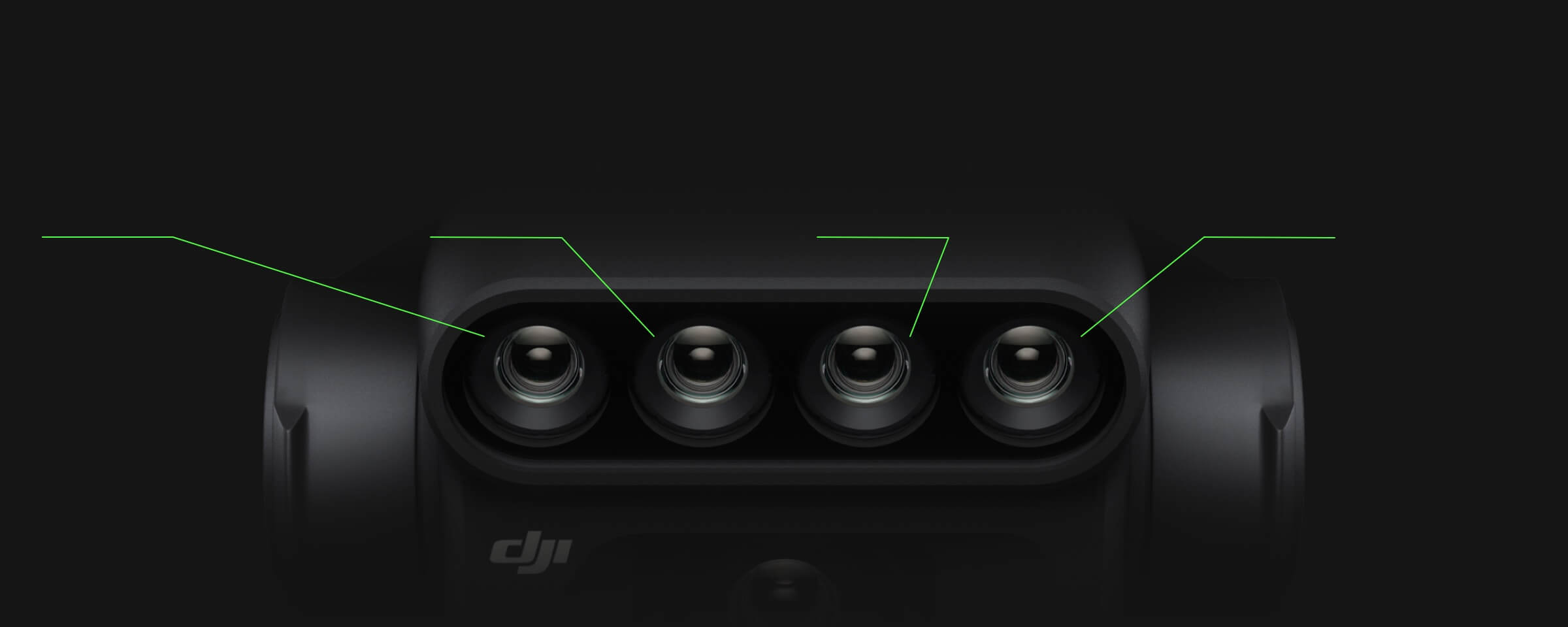
The RGB camera uses a 4/3 CMOS, the chip that catches the light, at 20 MP effective. The four multispectral cameras each read one band: green, red, red edge, and near infrared, which the eye cannot see. DJI's specification page puts them at 5 MP each; DJI's FAQ says 5.5 MP for the same sensor. The specification page centers the green band at 560 nm; the FAQ says 550 nm. Both numbers in both pairs are DJI's own, and we are not picking between them. There is no blue band. DJI's answer on that: NDVI, NDRE and GNDVI, the common crop health indices, use only two to three of the four bands present.
06
The sunlight sensor writes the light conditions into every image, and DJI documents no calibration panel
The sensor on top reads solar irradiance, the incident sunlight, and records it into the image file. DJI's product page puts the compensation itself during 2D reconstruction, in processing rather than on the aircraft. The raw image is a DN value, a digital number, not a reflectance value. DJI's image processing guide divides the camera's signal for a band by the sunlight sensor's signal for the same band. Factory calibration parameters carried in each image's metadata scale the result. Across DJI's product page, specification page, FAQ, user manual and image processing guide, DJI documents no external reflectance panel and no dedicated calibration flight. We report that gap in DJI's documentation and draw no conclusion from it about whether calibration matters. DJI does say NDVI cannot be obtained if the sensor is blocked, and that its surface must not be rubbed or scratched.
07
The maps come from DJI Terra or DJI SmartFarm, and the 1 cm figure is a position, not a map accuracy
The aircraft renders NDVI, GNDVI and NDRE live. DJI's specification page lists them as the multispectral camera's own video content, and its FAQ confirms they can be viewed on the controller during flight. The finished georeferenced maps come from DJI Terra or DJI SmartFarm Web, which DJI's product page attributes to the software rather than the aircraft. Budget for one of them. The RTK module reads 1 cm plus 1 ppm horizontally in Fixed RTK, and 1.5 cm plus 1 ppm vertically. That figure is where the aircraft knows it is. It is not the accuracy of an orthomosaic, the stitched flat map, and DJI publishes no mapping or orthomosaic accuracy figure for this aircraft. We also could not confirm what warranty or software terms our Shield Plus SKU includes. Call +1 888 850 6533, Monday to Friday, 9 to 5 Mountain Time, and we will confirm before you order.
FOR UNIVERSITIES, COLLEGES AND GOVERNMENT AGENCIES
Buying with a card? Checkout is above. Buying for an institution? All of this is routine
Checkout above. Financing available with Affirm.
Institutions only: universities, colleges and government agencies.
Attached automatically.
Send the certificate once, we hold it on file.
On request, for committee approval.
One person, from quote to delivery.
REFERENCE
Specifications
Cameras and sensors
| RGB camera | 4/3 CMOS, 20 MP effective pixels, FOV 84°, equivalent focal length 24 mm, aperture f/2.8 to f/11, max photo 5280×3956, max video 4K 3840×2160@30fps |
| Multispectral camera sensor | 1/2.8-inch CMOS, effective pixels: 5 MP (DJI's specs page). DJI's own FAQ separately states "four 5.5MP single-band cameras" for the same sensor. The two DJI sources disagree by 0.5 MP |
| Multispectral bands | Green (G): 560 ± 16 nm; Red (R): 650 ± 16 nm; Red Edge (RE): 730 ± 16 nm; Near infrared (NIR): 860 ± 26 nm (DJI's specs page). DJI's FAQ states the green band as "550 nm ± 16 nm", a 10 nm disagreement with the specs page |
| Multispectral video content | FHD 1920×1080@30fps, DJI's specs page states this video mode's content as "NDVI/GNDVI/NDRE": a live index render, distinct from the georeferenced vegetation-index maps DJI attributes to DJI Terra or DJI SmartFarm Web |
| Sunlight sensor | DJI's product page: "The built-in sunlight sensor captures solar irradiance and records it in an image file, allowing for light compensation of image data during 2D reconstruction. This results in more accurate NDVI results, as well as improved accuracy and consistency of data acquired over time." DJI's FAQ: avoid blocking it (NDVI cannot be obtained if blocked) and avoid rubbing or scratching its surface |
| How the reflectance correction actually works | DJI's Image Processing Guide: each band's reflectance is the camera's reflected-light signal divided by the sunlight sensor's incident-light signal for that band, scaled by a factory conversion parameter that calibrates every camera band and sunlight-sensor band against the standard NIR band. The parameters ship embedded in each image's XMP metadata. DJI documents no external reflectance calibration panel and no dedicated calibration flight for this product; the correction runs from the sunlight sensor plus stored factory calibration |
| Raw image value | DJI's FAQ: images are a DN (digital number) value, not a calibrated reflectance value; reflectance is derived downstream using the sunlight sensor signal and the factory calibration parameters above |
| Position compensation | DJI's FAQ: each of the five camera sensor centers is compensated in the photo EXIF coordinates relative to the onboard D-RTK antenna phase center; DJI Terra or DJI SmartFarm Platform uses this parameter automatically when mapping, to ensure the accuracy of the map position |
| Distortion and vignetting correction | DJI's FAQ and Image Processing Guide: distortions in the visible and multispectral cameras are individually corrected before shipping; the original photo has no vignetting correction applied, but the correction parameters are included in each photograph's metadata for processing software to apply |
| Gimbal | 3-axis mechanical (tilt, roll, pan); mechanical range tilt -135° to 45°, roll -45° to 45°, pan -27° to 27°; controllable range tilt -90° to 35°, pan uncontrollable |
Vegetation indices and processing
| Indices named by DJI | NDVI, NDRE and GNDVI, named explicitly in DJI's FAQ ("the NDVI, NDRE and GNDVI indices, commonly used for crop health monitoring, only use two to three of these four bands"). DJI's specs page separately lists "NDVI/GNDVI/NDRE" as the multispectral camera's own FHD video content |
| Live preview vs. finished maps | DJI's FAQ: NDVI "can be viewed in real-time on the remote controller during flight" (aircraft/app capability). DJI's product page: "DJI Terra or the DJI SmartFarm Web can then generate NDVI and other vegetation indices maps" (a separate, post-flight software capability). Both are DJI-stated facts about different things; neither should stand in for the other |
| Recommended acquisition conditions | DJI's FAQ: good light conditions and a sun altitude angle of at least 30° |
| GSD-to-altitude formulas | DJI's FAQ: visible camera orthophoto (H/37.2) cm/pixel; multispectral camera orthophoto (H/21.7) cm/pixel, where H is flight altitude |
| Missing band impact | DJI's FAQ: no blue band on this sensor; DJI states this has minimal impact on crop-growth and environmental monitoring because NDVI, NDRE and GNDVI only use two to three of the four bands present |
Flight performance
| Weight | 951 g with propellers and RTK module installed; max takeoff weight 1,050 g |
| Max flight time / hover time | 43 minutes / 37 minutes, windless, sea level, 36 kph constant, for reference only |
| Max flight distance | 32 km, tested in a windless environment at sea level at 57.6 kph until 0% power, for reference only |
| Max wind resistance | 12 m/s |
| Operating temperature | -10° to 40° C (14° to 104° F); DJI's Safety Guidelines state this as a hard DO NOT-fly limit, not a comfort range |
| Max takeoff altitude | 6,000 m above sea level, without a payload (specs page). DJI's FAQ separately states an operational "Flight Height" limit of 500 m; the two are different metrics (service ceiling vs. an app/regulatory flight-height default) and are not a contradiction |
| Coverage | Up to 200 hectares in a single flight (DJI's own marketing figure); no altitude, speed or overlap condition is stated alongside it |
| Hovering accuracy | Vertical ±0.1 m (Vision Positioning), ±0.5 m (GNSS Positioning), ±0.1 m (RTK); Horizontal ±0.3 m (Vision Positioning), ±0.5 m (HD Positioning), ±0.1 m (RTK) |
| Water resistance | DJI's FAQ, asked directly "Is DJI Mavic 3M waterproof?": "No." DJI publishes no IP rating for this aircraft on its product page, its specs page, its FAQ, its Safety Guidelines or its User Manual |
| Weather limits | DJI's Safety Guidelines: do not operate in wind exceeding 12 m/s, snow, rain, fog, hail or lightning |
RTK module
| Standard equipment | DJI's FAQ, asked directly: "Does DJI Mavic 3M come standard with the RTK Module?" "Yes." DJI's own In-the-Box PDF shows it pre-installed on the aircraft, with no separate RTK-module icon in the packing list |
| RTK position accuracy | Fixed RTK: Horizontal 1 cm + 1 ppm; Vertical 1.5 cm + 1 ppm. This is the RTK module's own positioning accuracy, not a stated orthomosaic or mapping-accuracy figure; DJI publishes no separate mapping-accuracy percentage for this product |
| Dimensions and weight | 50.2×40.2×66.2 mm, 24±2 g, USB-C interface, approximately 1.2 watts |
| GNSS with RTK | GPS + Galileo + BeiDou + GLONASS; GLONASS is only supported when the RTK module is enabled |
| Mobile station compatibility | DJI's FAQ, asked directly: "Does DJI Mavic 3M support D-RTK2 mobile station?" "Yes." Network RTK is also supported via the remote controller's own Wi-Fi, without a 4G/SIM card |
| PSDK port | DJI's FAQ: the PSDK port on the aircraft body supports the RTK Module and the official DJI Mavic 3 Enterprise Series Speaker only |
Battery
| Capacity and chemistry | 5,000 mAh, 15.4 V standard, LiPo 4S, Lithium Cobalt, 77 watt-hours, 335.5 g |
| Charging temperature | 5° to 40° C (41° to 104° F); DJI's Safety Guidelines state the ideal charging range as 22° to 28° C (72° to 82° F) |
| Charge cycle rating | DJI's Safety Guidelines: "The battery is rated for 200 cycles. The stability of the battery will be affected after the rated cycles. In this case, make sure to replace the battery." |
| Battery cautions | DJI's Safety Guidelines: no liquid contact, no dropping in water; no non-DJI batteries; no swollen, leaking or damaged batteries; no disassembly or piercing; no use after a crash or heavy impact; extinguish a battery fire with water, sand or a dry powder extinguisher; do not charge immediately after flight, allow it to cool first; do not store near heat sources, in direct sunlight or in a hot vehicle; do not store fully discharged for an extended period |
| Air travel | DJI does not publish an airline-carriage statement for this battery in its FAQ or its Safety Guidelines. The battery is 77 Wh |
Controller and transmission
| Controller compatibility | DJI's FAQ, asked directly: the standard DJI Mavic 3 Series remote controller does not work with the Mavic 3M; the DJI Mavic 3 Enterprise Series remote controller (RC Pro Enterprise Edition) does |
| RC Pro Enterprise Edition, supported aircraft | DJI's specs page: "DJI Mavic 3E / DJI Mavic 3T / DJI Mavic 3M." Footnote: "The DJI RC Pro will support more DJI aircraft in the future" |
| Video transmission | DJI O3 Enterprise Industry Edition; max effective signal distance FCC 15 km, CE/SRRC/MIC 8 km, unobstructed and interference-free; live view 1080p/30fps |
| Controller operating conditions | Operating temperature -10° to 40° C (14° to 104° F); charging temperature 5° to 40° C (41° to 104° F); internal battery approx. 3 hours operating time |
What it does not do
| FlightHub 2 | DJI's FAQ, asked directly: "Does DJI Mavic 3M support access to DJI Flighthub 2?" "Not currently." |
| Dual and multi-aircraft control | DJI's FAQ: dual control not supported; multi-aircraft control not supported |
| DJI Goggles | DJI's FAQ, asked directly: "Can DJI Mavic 3M be used with DJI Goggles?" "No." |
| Legacy flight modes | DJI's FAQ: timelapse, motionlapse, Follow Me, TapFly and Hyperlapse are not supported |
| Waterproofing | Not waterproof; no IP rating published by DJI for this product |
Software and support
| Guaranteed software updates until | 2024/12/31, DJI's own spec-page field |
| Firmware since that date | DJI's own Release Notes show firmware releases dated 2025-04-07, 2025-06-10, 2025-09-16, 2025-12-11, 2025-12-16 and 2026-05-07, all after the 2024/12/31 guarantee field. The Mavic 3M is explicitly named in the 2026-05-07 release ("DJI Mavic 3T/3E/3M") but is not named in the three releases dated 2025-09-16 through 2025-12-16 (which list only "DJI Mavic 3T/3E"). |
| Successor position | DJI launched the Matrice 4 Series (M4E, M4T) on 8 January 2025 as its new compact flagship enterprise series, and has published no multispectral variant of it. DJI's own product and specification pages for the Mavic 3 Multispectral remain live. |
| Processing software | DJI Terra or DJI SmartFarm Web/Platform generate vegetation-index maps from the aircraft's imagery; DJI's own product page attributes this step to the software, not the aircraft |
Ordering
| Dealer status | Authorized DJI Enterprise dealer |
| Purchase orders | Accepted from universities, colleges and government agencies |
| Shipping | Shipped direct from the manufacturer |
| Speak to us | +1 888 850 6533, Monday to Friday, 9 to 5 Mountain Time |